Overview
Dramatic advances in digital technology and progression in the digitalization of society as a whole triggered by the COVID-19 pandemic have led to major changes in our lifestyles. In the realm of city planning and urban development as well, recent years have seen efforts to realize the digitization of cities (urban digital twin) being implemented on a nationwide scale.
By accurately grasping these trends and while leveraging new technologies such as urban data and AI, at NSRI, we provide support for improving the efficiency and sophistication of day-to-day work for city planning and urban development at government offices and other organizations, and provide solutions and services that help enhance the attractiveness of cities through the fusion of the real world and digital technologies.
By accurately grasping these trends and while leveraging new technologies such as urban data and AI, at NSRI, we provide support for improving the efficiency and sophistication of day-to-day work for city planning and urban development at government offices and other organizations, and provide solutions and services that help enhance the attractiveness of cities through the fusion of the real world and digital technologies.
Features and Approaches
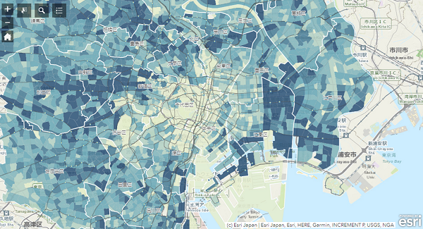
We are undertaking an initiative called the City Information Platform (CIP) to consolidate and update open data and other data on architecture and cities for utilization in visualizing and analyzing cities. We are focusing efforts on the development of original indexes such as the Walkability Index, with the aim to build a scheme for assessing cities from multiple angles as well as quantitatively and objectively.
In the area of DX of cities, we have been participating in Project PLATEAU as a project partner since its first year, and while collaborating with different industries, we are working on the utilization of 3D city models (use case development). We are also working to solve city and community issues through services such as supporting governments and other stakeholders in the formulation of smart city strategies and the development of smart services, and supporting the establishment of schemes for data-driven urban management.
In the implementation of such initiatives, while leveraging our know-how and extensive network with other industries and academia, we are able to take multifaceted approaches in each project phase, from the demonstration to application phases.
Service Details 1
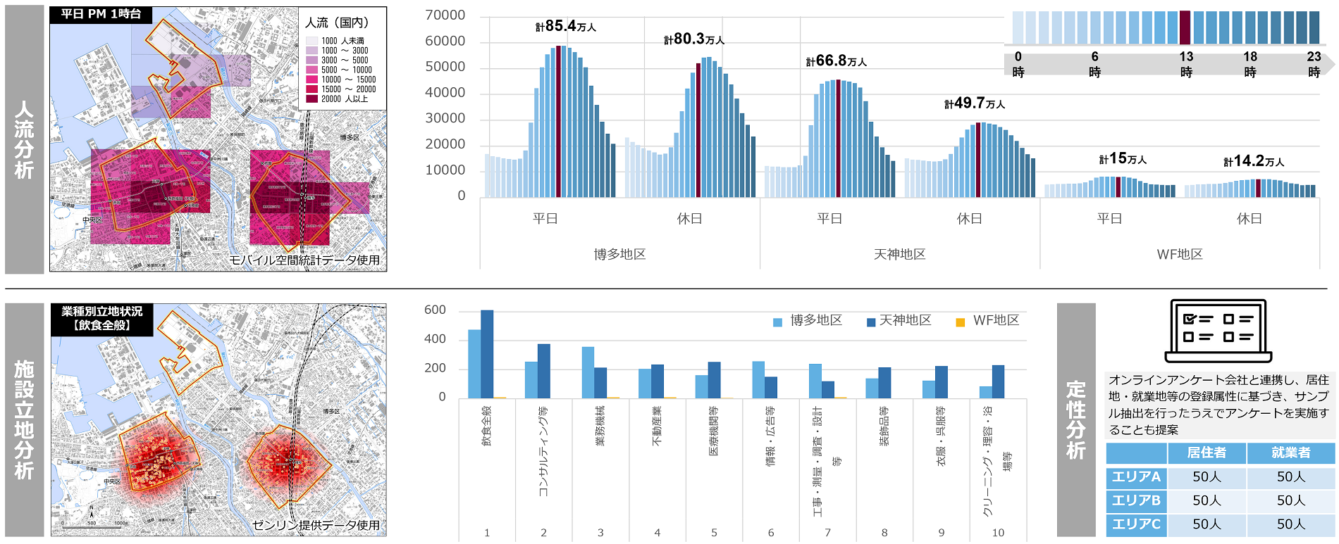
Urban analysis and assessment using the City Information Platform (CIP)
We support the development of information for higher added value by consolidating various data (including open data) closely associated with architecture and cities, as well as data such as energy and environment-related data that can be obtained through IoT and ICT. By also using these data for the visualization of cities and various city analyses, we support city planning and urban development through evidence-based policymaking (EBPM).
Service Details 2
Utilization of new urban data such as the Walkability Index
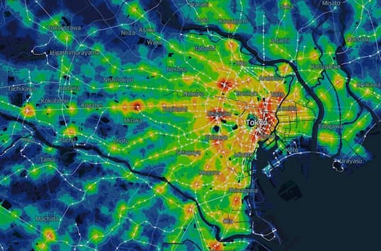
In collaboration with the University of Tokyo, we are developing the Walkability Index, a new evaluation index for real estate environments. The Walkability Index is an objective urban index that can be used nationwide to provide, on a 100-point scale, an easy-to-understand evaluation of the concentration of "urban amenities," which would make life more comfortable if they were within walking distance of a given location. Utilizing such new urban data, we support studies such as location-specific analyses, the effectiveness of large-scale projects, area assessments and branding.
Service Details 3
Support for digitization and openness of data such as city planning and real estate-related information
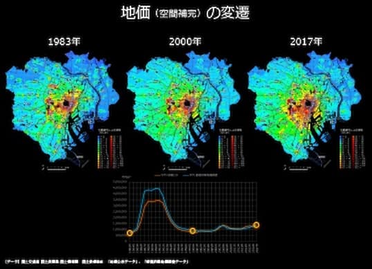
Digitization (standardization), data utilization, and openness of data of city planning information and real estate-related information are being promoted to advance government digitalization and EBPM, and to generate open innovation in the private sector. We have a long track record in examining the formulation of relevant national guidance and guidelines, and by linking urban development plans with the organization and utilization of "usable" data, we support the implementation of well-grounded, data-based studies.
Service Details 4
Use case development utilizing the 3D city model, PLATEAU
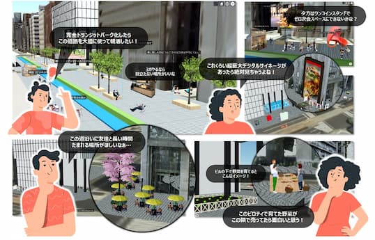
As a project partner of Project PLATEAU, while working together with other industries, we are engaged in use case development using a 3D urban model. Notably, we propose use cases that leverage the strengths of the Nikken Group, including support for urban development using XR technology (citizen workshops and stakeholder consensus building), and more efficient and sophisticated urban development using buried object models.
Service Details 5
Support for the development of smart city strategies and smart services
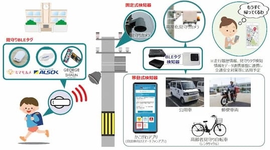
Smart city initiatives are being implemented throughout Japan, but the transition from the demonstration phase to the social application phase is challenging. Utilizing our accumulated know-how on architecture and cities, we support governments and other organizations in formulating smart city strategies, develop smart services by teaming up with different industries, and support the utilization of urban OS. In this way, we make highly effective proposals for building data-driven urban management systems and for finding solutions to urban and community challenges.
Service Details 6
Support for drafting area branding strategies based on data
With population and functions concentrating in Tokyo and other metropolitan areas, competition among areas is intensifying for local governments and local businesses. This makes area branding necessary for differentiation and attraction of more investment. After drawing up a hypothesis by identifying area features through coordination with local stakeholders and other efforts, various approaches, such as data analysis or questionnaire surveys, befitting those features are taken to support the drafting of strategies that will enhance area branding.